Koshutan, the beautiful destination of Rugova Mountains

· updated · 2 min read
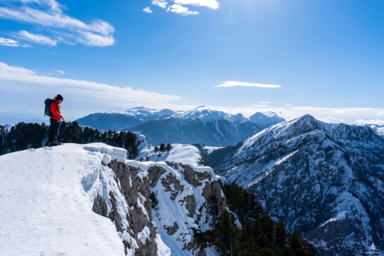
A hiker on a snowy trail among pine trees at Koshutan, with distant mountains beneath a cloudy winter sky
Koshutan, Kosovo
Distance
14.0 km
Ascent
+796 m
Descent
−26 m
High point
2,152 m
Water
No water sourcetake around 2 litres

The route

Koshutan, on the map

From my own GPX track. Move along the elevation profile or along the line on the map: both show the same point.

Distance14.0km
Ascent+796m
Descent−26m
High point2,152m

Walking time at your paceAn estimate without breaks, worked out from the distance and the climb.

  • Relaxed6 h 5 min
  • Average4 h 50 min
  • Fast3 h 55 min

Elevation

Elevation profile of Koshutan, the beautiful destination of Rugova MountainsStarts at 1,368 m, climbs 796 m in total to a high point of 2,151 m after 6.5 km, and finishes at 2,151 m; 6.6 km in all.1,500 m2,000 m0 km1 km2 km3 km4 km5 km6 kmKoshutanMaja e Dromidolit

How steep

  • 1.7 kmUnder 8%
  • 3.7 km8 to 15%
  • 0.5 km15 to 25%
  • 0.7 kmOver 25%

Embed this map

Paste this into your page or post (in WordPress: a Custom HTML block). The map stays up to date with the guide, and the link under it leads your readers to the full guide.

What to pack12 things, for a summit

Every hike

For the summit

The light for photographs

Today at Maja e Dromidolit: sunrise 06:26, sunset 16:20.

Today at Maja e Dromidolit: sunrise 06:26, sunset 16:20.

At Maja e Dromidolit, 2,151 m, in local time (Europe/Belgrade), with an open horizon: the mountains around can hide the sun sooner.

In short

This 14 km hike starts in Koshutan, in Kosovo’s Rugova Mountains, and climbs to Maja e Dromidolit at 2,152 m. The ascent is 796 m. The post does not state a hiking time or difficulty, and there is no water source, so take around 2 litres.

If you are planning to visit and hike in Kosovo, Rugova mountains is a must. Located in north-west part of Kosovo, in the border between Kosovo and Montenegro is a region within the Accursed Mountains (Prokletije). 

Koshutan is not a very popular outdoor destination. The reason for this is the fact that the road was unpaved and difficult passable. But, in my opinion, is one of the most beautiful and panoramic destinations there.

From Koshutan you can hike to some peaks like Maja e Dromodolit (Dromodol peak), Hajla e Vranovcit (Hajla e Koshutanit) and Hajla e Shkrelit.

In this post, I will describe the hike from Koshutan to Maja e Drmdolit.

A hiker on a snowy trail among pine trees at Koshutan, with distant mountains beneath a cloudy winter sky

How to get to Koshutan, Rugova Mountains

Koshutan is 23 km from the Patriarchate of Peja. Peja is a great city surrounded by the Accursed Mountains. Reaching the city Peja is very easy. There is a train going two times per day from Prishtina to Peja. Also,  you have a bus going from the capital of Kosovo, Prishtina to Peja every hour (from Prishtina main bus station). It’s the same if you are going from Prizren to Peja.

There is no bus going from Peja to Koshutan, Rugova Mountains, so you need a private car or a taxi.

About the Koshutan to Dromidol peak hike

A hiker crosses a snowy ridge above forested valleys in the Rugova Mountains under a cloudy winter sky

From Koshutan you need to continue ascending through a forest. You just need to follow the road for around 4 km. When you will arrive at the last mountain huts, you will see a huge peak in front of you. This is Maja e Dromidolit peak. You will continue hiking through for around 2 km and then start ascending to the peak. When you reach the peak the views are incredible! During the winter be prepared for a lot of snow.

There isn’t any water source, therefore take around 2 liters of water. The total distance is 14 km.

Points of interest:

Starting point: Koshutan, Peja

Starting altitude: 1’366 m/alt

Highest altitude: 2’152 m/alt

Elevation gain: 796 m/alt

Share this guide

Questions and comments

Ask me about this hike

Leave a comment or a trail report

Your email is never shown. A first comment appears once I have read it.

Trail report

Through my lens

More from Kosovo

All my photographs

Keep exploring

More from Accursed Mountains

All Kosovo guides
Granit Temaj

Get my new stories by email

Be the first to know when I come back from the mountains with a new route.

You will get one email to confirm. Unsubscribe any time. Privacy

Read the guide

Trail alerts

An email when someone reports how the path is, or when I update the guide. Nothing else, and one click stops it.

You confirm it by email first. Your address is used for these alerts only. Privacy

License this photograph

Tell me what it is for. I answer within a few days with a price and the licence.

Your name and email are used only to answer this request.

Newsletter

Get my new stories by email

Be the first to know when I come back from the mountains with a new route.

You will get one email to confirm. Unsubscribe any time. Privacy