At the foot of Zugspitze (2,962 m), Germany’s highest mountain, lies Eibsee — a lake so clear it feels almost unreal. Just 1.5 hours south of Munich, it’s one of Bavaria’s most rewarding day hikes: turquoise islands, perfect reflections, and mountain air that feels like glass.

I’ve visited Eibsee multiple times, in both summer and winter. Each season transforms the lake — from a green mirror of pines to a frozen mosaic under snow. But no matter when you come, walking the full loop is the best way to experience it.

Overview
Trailhead: Eibsee Parkplatz, Grainau (47.457756008241205, 10.991600055333967)
Distance: 7.3 km (loop)
Elevation gain: 210 m
Difficulty: Easy
Time: 2–3 h
Max elevation: 1,041 m
Trail type: Loop
The Eibsee Circuit Trail
Starting directly from the Eibsee Hotel parking area, the trail loops around the entire lake — an easy, scenic circuit that rewards every step with new angles of turquoise and rock.
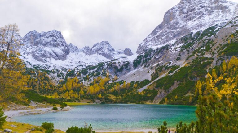
The path alternates between shaded forest and open viewpoints. From the eastern side, you see the Zugspitze rising straight out of the water, often mirrored perfectly on still days. Along the way, small gravel beaches invite quick stops — perfect for a swim or just to sit and watch the changing colors of the lake.
Halfway around, a wooden jetty offers a wide view of Sasseninsel, one of Eibsee’s eight small islands. When the light hits right, the water here glows from emerald to deep sapphire — one of Bavaria’s most photographed spots.
The western side is quieter and wilder, with fewer people and more forest. A few short ascents give you higher vantage points, but overall the trail remains gentle and accessible year-round.
Getting There
From Munich by Train & Bus
-
Take a regional train (RB/RE) from München Hauptbahnhof to Garmisch-Partenkirchen (1 h 20 min).
-
From there, take Bus 3 or 4 toward Eibsee (20 min).
-
Total travel time: ~2 h. The Bayern Ticket/Deutschland Ticket covers both train and bus.
By Car
-
90 km from Munich, around 1.5–2 h drive.
-
Parking at Eibsee Parkplatz
-
Early arrival recommended, especially in summer.
When to Visit
-
Spring: Quiet trails, melting snow, fresh air.
-
Summer: Swimming, kayaking, bright turquoise water.
-
Autumn: Best colors — gold and blue contrasts.
-
Winter: Silent, frozen lake; snowshoe trails open.
The light is best in the morning (09:00–11:00) when the sun hits Zugspitze’s face and the lake glows emerald.

Things to Do at Eibsee
-
Hike: The 7.3 km circuit trail.
-
Swim: Allowed in designated areas — the water is cold but crystal clear.
-
Boat: Rent rowboats, pedal boats, or electric boats at the pier.
-
Zugspitze Cable Car: The base station is next to the parking lot — take it up to 2,962 m for panoramic views over Germany, Austria, and Italy.
-
Photography: Bring a polarizing filter to cut glare and capture the lake’s gradient colors.
Tips
-
Arrive early or visit late afternoon to avoid crowds.
-
Drones are not allowed at Eibsee.
-
No camping or overnight stays.
-
Bring layers — mountain weather changes fast.
-
Cafés and restrooms are available near the hotel and cable car.
Nearby Highlights
-
Grainau: Small Alpine village 5 min away, good for overnight stays.
-
Garmisch-Partenkirchen: 15 min drive — great restaurants and hiking base.
-
Partnach Gorge (Partnachklamm): A must-visit canyon with waterfalls and tunnels.

Why Eibsee Matters
Eibsee isn’t just beautiful — it’s perfectly balanced. Mountains, forests, water, and silence coexist in one frame. Whether you hike the full loop or just sit by the pier watching clouds drift across Zugspitze, this lake captures everything that makes the Bavarian Alps special: clarity, stillness, and scale.

Practical Info
Trailhead: Eibsee Parkplatz, Grainau
Distance: 7.3 km loop
Elevation gain: 210 m
Time: 2–3 h
Difficulty: Easy
Access: Free, open year-round
Region: Bavaria, Germany
Leave a comment or a trail report