Hiking to Unterer Gaisalpsee — A Cool Escape in the Allgäu Alps

· updated · 2 min read
A hiker sits above a waterfall below Unterer Gaisalpsee, with green alpine slopes and rocky peaks in summer sunlight
Hiking to Unterer Gaisalpsee, Germany
Distance
10.9 km
Time
~2 hup, 1.5 h down
Ascent
+724 m
Descent
−724 m
High point
1,508 m
Difficulty
Moderate

The route

Hiking to Unterer Gaisalpsee, on the map

From my own GPX track. Move along the elevation profile or along the line on the map: both show the same point.

Distance10.9km
Time~2 hup, 1.5 h down
Ascent+724m
Descent−724m
High point1,508m
DifficultyModerate

Walking time at your paceAn estimate without breaks, worked out from the distance and the climb.

  • Relaxed6 h 30 min
  • Average5 h 15 min
  • Fast4 h 10 min

Elevation

Elevation profile of Hiking to Unterer Gaisalpsee — A Cool Escape in the Allgäu AlpsStarts at 864 m, climbs 724 m in total to a high point of 1,526 m after 5.5 km, and finishes at 870 m; 10.3 km in all.1,000 m1,500 m0 km1 km2 km3 km4 km5 km6 km7 km8 km9 km10 kmReichenbachUnterer Gaisalpsee · 1,526 m

How steep

  • 3.1 kmUnder 8%
  • 2.9 km8 to 15%
  • 3.0 km15 to 25%
  • 1.3 kmOver 25%

In two parts

Embed this map

Paste this into your page or post (in WordPress: a Custom HTML block). The map stays up to date with the guide, and the link under it leads your readers to the full guide.

What to pack11 things, for a swim

Every hike

Water and sun

The light for photographs

Today at Unterer Gaisalpsee: sunrise 07:03, sunset 17:00.

Today at Unterer Gaisalpsee: sunrise 07:03, sunset 17:00.

At Unterer Gaisalpsee, 1,526 m, in local time (Europe/Berlin), with an open horizon: the mountains around can hide the sun sooner.

In short

The Unterer Gaisalpsee hike starts in Reichenbach near Oberstdorf and follows a 10.9 km loop with 724 m of ascent. It is a moderate hike, taking about 2 hours up and 1.5 hours down. The best season is May to October; carry 1 L of water per person and refill only at the lake.

There are days when you don’t want a summit — just a quiet lake, cold water, and a long breath of alpine air.
Unterer Gaisalpsee, hidden above the village of Reichenbach near Oberstdorf, delivers exactly that: a two-hour climb ending at one of Bavaria’s most inviting mountain lakes.

A hiker sits above a waterfall below Unterer Gaisalpsee, with green alpine slopes and rocky peaks in summer sunlight

The Setting

The Allgäu Alps are Bavaria’s softer side — green meadows, wood huts, waterfalls, and steep peaks that still feel wild.
The trail to Unterer Gaisalpsee (1’508 m) follows this rhythm perfectly: waterfalls, forest, flowers, and finally a cold blue lake framed by Rubihorn’s rocky slopes.

From the parking lot in Reichenbach (860 m), you follow signs marked Gaisalp. Two paths start the journey — take the one that climbs through the narrow Reichenbachtobel gorge. It’s steeper and wetter but far more scenic, a series of small cascades and bridges tucked between moss-covered walls.

After half an hour, the gorge opens into pastures and the real climb begins — a narrow alpine trail winding through roots and stone, occasionally giving views back over the Iller valley.
And then the forest thins, the light changes, and the lake appears: green grass, clear water, quiet wind.

Trail Data

Metric Value
Distance: 10.9 km (loop)
Elevation gain/loss: 724 m
Max elevation: 1’508 m/alt
Min elevation: 860 m
Difficulty: Moderate
Time: ~2 h up, 1.5 h down
Trail type: Loop

The path is stony but never exposed — ideal for confident beginners or anyone after a half-day alpine hike with a clear goal and a reward at the top.

Unterer Gaisalpsee hike

The Lake

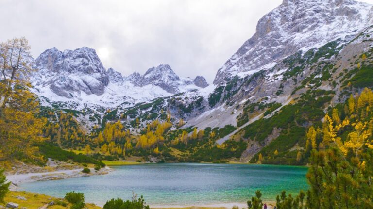
Unterer Gaisalpsee beneath green slopes and rugged Allgäu Alps, with a waterfall dropping over a rocky foreground

Unterer Gaisalpsee is one of those lakes that looks gentle but stays cold all year. Even in July, the water rarely passes 10 °C. Still, on a hot day, there’s no better swim.
The shore is wide enough for everyone to find their own patch of grass. Sit, eat, or watch reflections shift with the clouds.

The ambitious can continue another hour to Rubihorn (1,957 m) or Geißfußsattel, gaining full views over Oberstdorf and the Nebelhorn ridge. But most people stop here — and they’re right to.

Lower Gaisalpsee

Getting There

  • Start: Village of Reichenbach (near Oberstdorf, Allgäu)

  • Parking: Two lots before the village — one large paid, one small free.

  • Public transport: Train to Oberstdorf → Bus to Reichenbach (stop “Reichenbach bei Oberstdorf”).

  • Season: May–October. The gorge path can be slippery after rain; avoid in winter.

Notes for Hikers

  • Footwear: Sturdy hiking shoes — roots and wet rock.

  • Water: Carry 1 L per person; refill only at the lake.

  • Swimming: Allowed; water is cold but clean.

  • Best light: Morning sun hits the lake from the east; afternoon brings reflections.

  • Families: Good for fit kids 10 +.

Reflections

Some hikes challenge; others reset. Unterer Gaisalpsee does the second.
It’s a small pocket of alpine calm — waterfalls at the start, mountain air at the top, and a lake that forces you to slow down because it’s too cold to rush in.

The Allgäu doesn’t shout. It whispers — and this hike is one of its clearest sentences.
Share this guide

Questions and comments

Ask me about this hike

Leave a comment or a trail report

Your email is never shown. A first comment appears once I have read it.

Trail report

Through my lens

From this walk

All my photographs

Keep exploring

More from Bavarian Alps

All Germany guides
Granit Temaj

Get my new stories by email

Be the first to know when I come back from the mountains with a new route.

You will get one email to confirm. Unsubscribe any time. Privacy

Read the guide

Trail alerts

An email when someone reports how the path is, or when I update the guide. Nothing else, and one click stops it.

You confirm it by email first. Your address is used for these alerts only. Privacy

License this photograph

Tell me what it is for. I answer within a few days with a price and the licence.

Your name and email are used only to answer this request.

Newsletter

Get my new stories by email

Be the first to know when I come back from the mountains with a new route.

You will get one email to confirm. Unsubscribe any time. Privacy