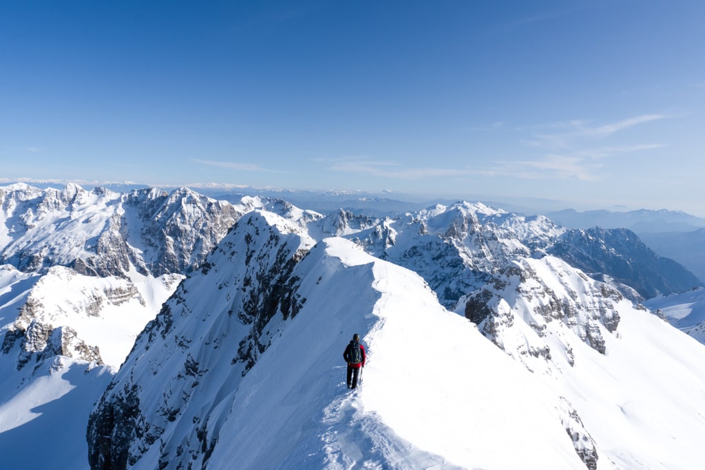
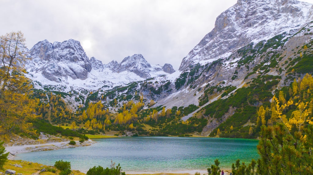
Maja Jezercë, the highest peak of Prokletije (the Accursed mountains), is also known as the “Queen of the Alps”. With an elevation of 2694 m/alt. Amazing views during the path!
There are several ways of climbing this mountain. The most popular one is starting from Fusha e Gjes’ in Valbona Valley to Maja Jezercë.
How to get to Valbona Valley National Park
Valbona Valley is 22 km from the city called Bajram Curri. Reaching Bajram Curri from Tirana takes around four hours. The bus station in Tirana is in front of the Asllan Rusi Sports Center.
Another way to reach Bajram Curri is from Prishtina, Kosovo. First, you go from Prishtina Main Bus Station to Gjakova Bus station, and then from Gjakova, take the bus to Bajram Curri.
Where to sleep and eat
Valbona Valley is a charming destination that offers a variety of accommodation options. Among these, the Guesthouses stand out for their affordability, traditional charm, and warm atmosphere. With delicious food on offer, staying in one of these guesthouses is an experience not to be missed.
During the summer months, Valbona Valley is a popular spot for tourists, and the Guesthouses quickly fill up. To avoid disappointment, booking your accommodation well in advance is wise. By doing so, you can secure your spot in one of these cozy and welcoming guesthouses, ensuring that your stay in Valbona Valley is memorable.
About the Valbona to Maja Jezercë hike
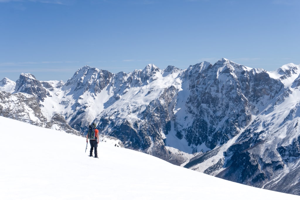
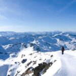
Reaching the summit of Maja Jezerce is an unforgettable adventure, but it’s not for the faint-hearted. With a total ascent and descent time of around 10 hours (14 hours during winter), starting hiking early in the morning is crucial to avoid running out of daylight. As you make your way up the mountain, be prepared for rocky terrain and ensure you bring a helmet for added protection.
During certain times of the year, crampons and an ice axe may also be necessary, particularly in areas affected by snowfall. While Maja Jezerce can be climbed year-round, it’s important to be mindful of the conditions and avoid dangerous routes.
The journey to the summit begins in Fusha e Gjes, Valbona Valley, passing through the small village of Rrogam before reaching the last water source at the “Te Simoni” bar during the spring. From there, follow the trail and keep an eye out for a small sign indicating the left path to the village of Theth (Valbone – Theth), or the right path to Maja Jezerce.
On the ascent, you’ll encounter a fixed rope near the summit, which can provide an added boost of confidence as you make your way to the top. However, be sure not to confuse the trail with another peak near Jezerca, known as Popluka Peak. With proper preparation and attention to detail, the summit of Maja Jezerce can be an unforgettable highlight of your hiking journey.
Points of interest:
Starting point: Fusha e Gjes’, Valbona
Starting altitude: 949 m/alt
Highest altitude: 2’694 m/alt
Elevation gain: 1’745 m/alt
Here is the summer trail (without snow):
Here is the winter trail (with snow):
You can buy me a beer to support me and my content! 🍺
Accursed Mountains Featured Hiking Mountains Prokletije
Last modified: September 22, 2025


[…] amazing outdoor destination located near the highest peak of the Accursed Mountains (Prokletije), Maja Jezercë. The easiest way to go to the lakes is from Vusanje in Montenegro. But, if you want an off-trail […]
[…] The trail is well marked and many tourists are doing it every day. But, you need to make sure you will not mix the signs. Some tourists, in a part of the trail, mix the signs and follow the path to a peak. You need to take the left to go to Theth. If you follow the right path, you reach the highest peak of the Accursed mountains – Maja Jezerce 2694 m/alt: […]
did you do it without a guide? So the path is well marked and with a good GPS, can it be done? some very complicated step? regards
I am a hiking guide :).
Yes, it is possible with a good GPS, but the trail is not very well signed.
Granit
Hi,
Is it possible to do the hike without any gear in the end of May? My girlfriend and I are looking for an adventurous hike. We are both in good shape and up for a challenge but it should be safe. What is the average temperature during this time of the year (May)? And do you know a place to stay overnight near cafe Te Simoni, without a tent? We would like to do (1st day) Theth to Te Simoni (close to there) and (2nd day) go to the top and hike back to Valbona to stay in a guesthouse over there.
Robin
Hi Robin, no, during May, the Maja Jezerce peak has a lot of snow, and I wouldn’t prefer it.
[…] is a fantastic outdoor destination near the highest peak of the Accursed Mountains (Prokletije), Maja Jezercë. The easiest way to go to the lakes is from Vusanje in Montenegro. But, if you want an off-trail […]
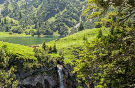
[…] hiking peak. During the hike, you can see and enjoy the view of Valbona Valley, Maja e Thate Peak, Maja Jezerca Peak, Karanfilat range of peaks, Vajusha Peak, etc. So, the view during the hike is 360 degrees and […]
Hey,
nice tour and pictures !:)
I want to do the hike in end of October if the conditions are fine.
Is this the normal route to start from Valbona? I read that you can also start in Theth?
Is 11:30/12 hours realistic including breaks?
Would you suggest to sleep somewhere on the way up (tent)?
Hi, thanks!
Yes, October is fine, but be careful since it gets darker earlier.
From Theth is quite a long distance, so I am unsure if you can do it in one day.
Would it be possible to pair up Theth-Valbone trail with a hike up to Maja Jezerce (starting at Rrogam and ending at Theth)? I was thinking late October, would this fit in one day if I start early in the morning? Thanks in advance for the information
Hi Jasper,
It is possible, but you need to be aware that this is an extreme one, and I am not sure of your fitness level.
Also, make sure to start very very early since the day will be much shorter at that time.
Hi Granit! First of all, thanks a lot for such a cool blog!
I just wanted to kindly ask you, how is it to hike to Maja Jezercë in August (from Valbona, since I have read that it is the “normal” route). Are ice-axe and crampons needed? I guess that in August there will not be much snow, but it is just to be sure what are the usual conditions in this season.
Thanks a lot in advance. Best regards, from the Basque Country, Spain!
Hey Ignacio,
Thanks a lot! Usually during August, there is no snow, so you don’t need ice-axe or crampons. However, I would recommend you wearing a helmet.
Granit
Hello! your post was very useful!!
I am going to try to do this hike during the end of August, I am seriously concerned about the weather and what I should wear. Since I am not very experienced with long hikes like this and I will be going alone I will be starting at sunrise in Rragam instead of Rrogam so I can take some breaks and hopefully finish the hike before night fall (if I end up deciding that I will go to the peak and not stop midway)
I have found this site that tells you the weather about the peak https://www.mountain-forecast.com/peaks/Maja-Jezerce/forecasts/2694
But it I havent found any recorded weather conditions during August in the internet
If there is little snow can I still do it with trekking poles? (I am 100% going to buy some in Shkoder before going to Valbvona, Im just asking if it is possible with just trekking poles)
Hi Aggelos,
Let me try and respond all of your questions:
1. You should definitely check the weather. Mountain-forecast is the best weather forecast to check.
2. To be honest, I wouldn’t recommend this hike to not experienced hikers. It is quite long, and in some parts, dangerous too.
3. I would highly recommend using trekking poles.
Stay safe!
Granit