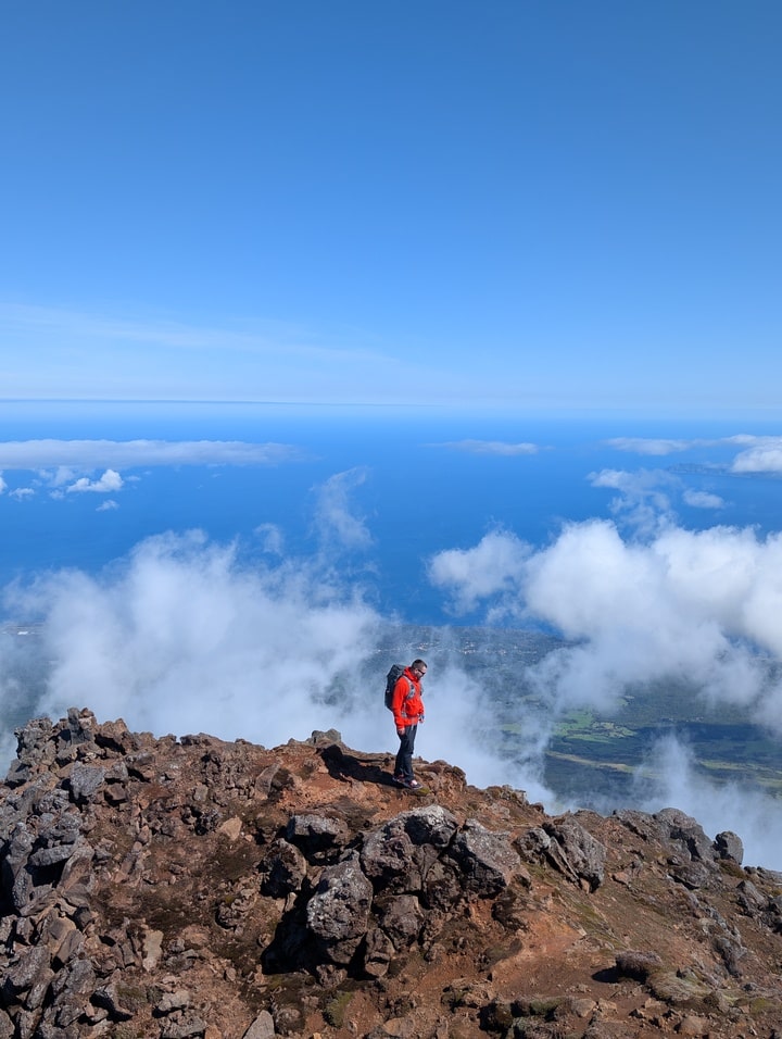
Mount Pico (2,351 m) is not just the highest point in Portugal — it’s a test of patience, lungs, and respect for nature. Rising dramatically from the island of Pico in the Azores, this dormant volcano towers above the Atlantic like a pyramid of black lava and cloud.
I climbed Pico in April, and while the ascent was manageable, the descent turned into a brutal reminder of how fast weather changes here — wind, fog, and rain hit hard. Still, the experience was unforgettable. If you’re planning to climb it, this guide will give you everything you need to know — logistics, gear, timing, and survival of the descent.
Overview
Distance: 7.98 km
Elevation gain: 1,148 m
Highest point: 2,351 m
Difficulty: Difficult
Time: 6–8 hours
Type: Out & back
Trailhead: Casa da Montanha (Mountain House), Pico Island
Coordinates: 38.471°N, 28.398°W
Official info & booking: montanhapico.azores.gov.pt
About Mount Pico
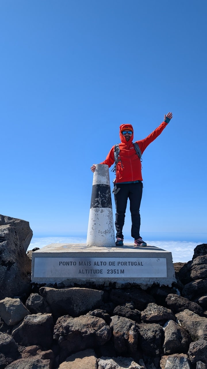
Pico is a stratovolcano — steep, symmetrical, and geologically alive. At the top lies the Pico Alto crater (500 m wide, 30 m deep), and within it, a smaller cone called Piquinho — the true summit, another 70 vertical meters up. It last erupted in 1720, and the ground still exhales heat near the peak.
Standing at 2,351 meters, Pico is more than twice the height of any other mountain in the Azores, and the highest point along the Mid-Atlantic Ridge — Europe’s geological frontier with North America.
How to Register and Start the Climb
All hikers must check in at Casa da Montanha (Mountain House), located at 1,200 m elevation — already halfway up the volcano. It’s mandatory to register, get a GPS tracker, and attend a short safety briefing.
Booking:
-
Reserve your permit at least 2–3 days in advance on the official website.
-
Only 160 climbers are allowed on the mountain at any one time (80 ascending, 80 descending).
Entry Fee: ~€25 per adult (includes GPS tracker and safety briefing).
Operating Hours: 06:00–22:00 (climbers must return by night).
Parking: Free spaces available near the Mountain House.
Facilities: Toilets, water, and basic weather information.
Trail Breakdown
There are 47 numbered poles marking the official route to the summit. Pole #47 is the crater; from there, it’s another 70 m scramble up Piquinho.
Segment overview:
-
#1–#15: Forest and shrubs. Soft ground, moderate incline.
-
#16–#30: Exposed lava field. The incline gets steep — bring poles.
-
#31–#44: Rocky terrain, loose gravel, tiring.
-
#45–#47: Crater rim. Strong winds likely.
-
Final 70 m (Piquinho): Steep rock climb using hands; hot steam vents from the ground.
The final push is short but intense — volcanic rock, slippery dust, and the smell of sulfur.
Weather and Best Time to Climb
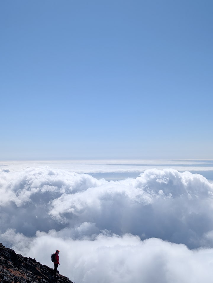
Pico’s weather can change faster than any other place in the Azores.
Best season:
-
June–September: Clearer skies, more stable weather.
-
April–May & October: Unpredictable, colder, foggy (as I experienced).
-
November–March: Not recommended; snow and strong wind common.
Time of day:
-
Morning climbs (7–8 AM start) are safest.
-
Night/sunrise climbs (2–3 AM start) are magical but require a guide and good headlamps.
-
Avoid late afternoon starts — storms build quickly.
Map
Guided vs. Solo
You can climb Pico with or without a guide, but the difference is huge.
| Option | Pros | Cons |
|---|---|---|
| With guide | Safer, motivational, guaranteed summit route, weather insight | €60–90 per person |
| Solo | Flexible, cheaper, full independence | Riskier in fog/rain, route-finding harder near summit |
If it’s your first time, take a local guide. I went solo.
What to Pack
Mandatory gear:
-
Sturdy hiking boots with ankle support
-
Waterproof jacket (trust me, you’ll need it)
-
2–3 L water
-
Snacks: nuts, chocolate, energy bars, sandwiches
-
Headlamp (especially for early or late hikes)
-
Gloves (lava rock tears skin easily)
-
Layers (temperature drops 10–15°C from base to summit)
-
GPS device (provided by Mountain House)
Optional but smart:
-
Trekking poles
-
Power bank
-
Knee support for the descent
The Descent — Harder Than the Climb
Almost everyone underestimates the descent. I did too.
The loose volcanic rock turns into a slippery mix of gravel and ash, and after hours of uphill effort, your legs are too shaky to absorb impact. My descent was in heavy fog and rain — visibility 5 meters, wind slicing sideways.
Expect:
-
2–3 hours down.
-
Constant balancing on unstable ground.
-
Knee strain and fatigue.
Take it slow, use poles, and follow the pole numbers in reverse order to avoid losing the trail.
Overnight & Sunrise Climbs
If you want to camp overnight at the crater:
-
You must request an additional overnight permit when registering.
-
Tents can be set up inside the main crater only (not on Piquinho).
-
Expect strong winds and freezing temperatures, even in summer.
Many hikers combine sunset + sunrise, sleeping at the crater rim — one of the most surreal experiences possible in the Azores.
9. Safety and Regulations
-
Permit required: yes, always.
-
Drone use: forbidden without authorization.
-
Weather alerts: check at Casa da Montanha before starting.
-
Rescue service: included in your permit (use GPS beacon if needed).
-
Leave no trace: lava terrain is fragile — stay on marked path.
Final Thoughts
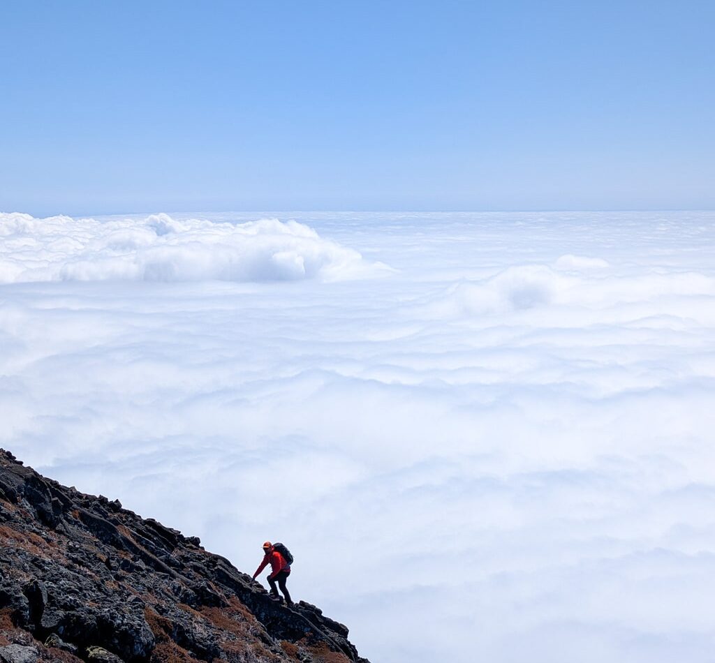
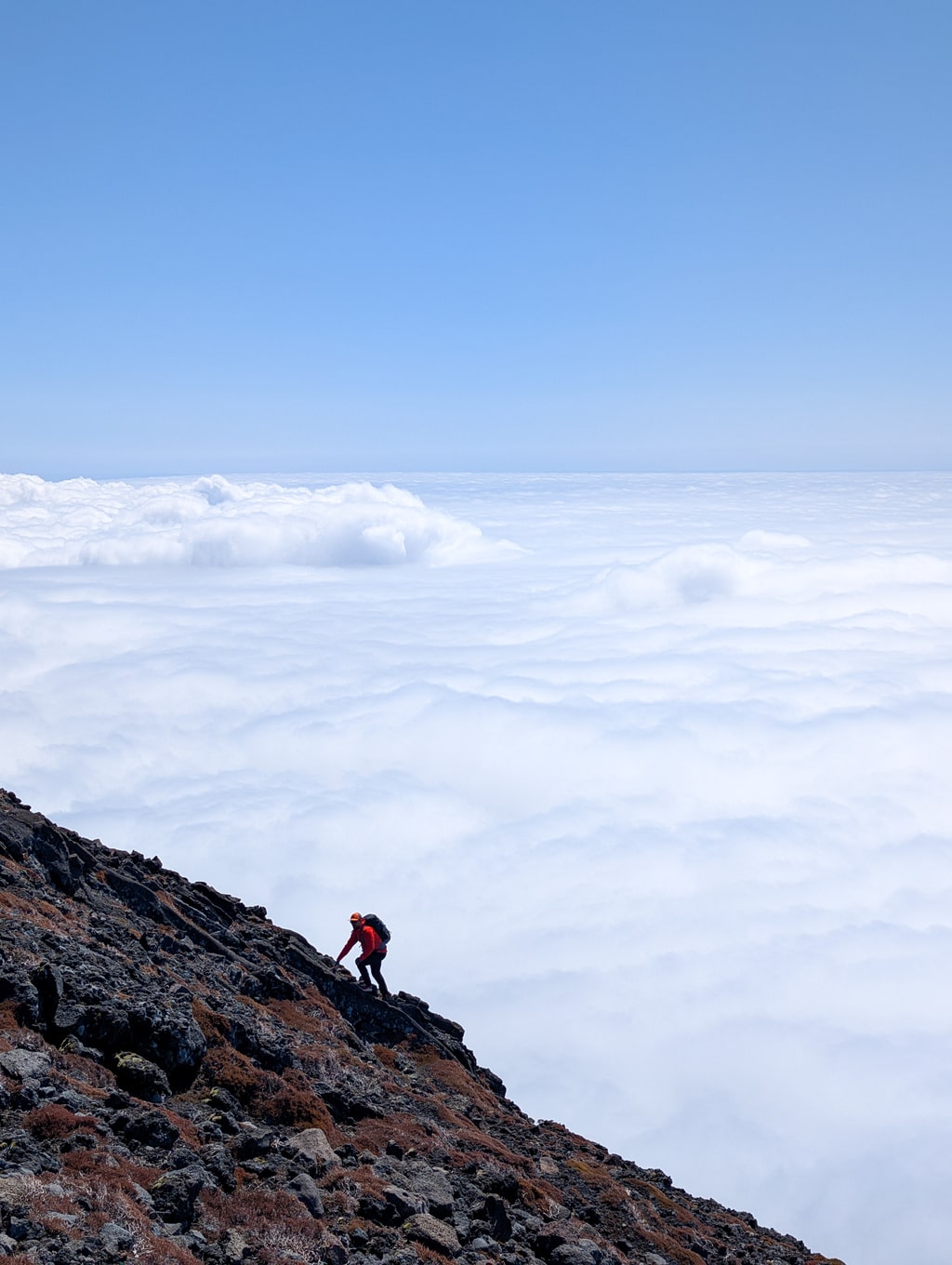
Mount Pico is not a “pretty hike.” It’s steep, raw, and unpredictable. But that’s what makes it special.
Reaching the summit feels like standing on the roof of the Atlantic — clouds swirling below, the smell of sulfur, the silence breaking only by wind and breath. And when you come down, sore, soaked, and proud, you’ll know why this volcano leaves such a mark on everyone who climbs it.
Even with brutal weather on the descent, I’d do it again — and next time, I’ll aim for the sunrise.
Practical Info
Trailhead: Casa da Montanha, Estrada da Montanha, São Roque do Pico
Website & booking: montanhapico.azores.gov.pt
Best season: June–September
Permit: Mandatory
Duration: 6–8 hours round trip
Elevation gain: 1,148 m
Difficulty: Difficult
Last modified: October 22, 2025