Exploring Maja e Taraboshit and Maja e Golishit: An Adventure You Don’t Want to Miss

· updated · 2 min read
A hiker follows the rocky green ridge of Maja e Taraboshit above the blue Adriatic Sea
Exploring Maja e Taraboshit and Maja e G…, Albania
Distance
17.9 km
Ascent
+710 m
Descent
−707 m
High point
651 m
Difficulty
Easy
Season
Spring

The route

Exploring Maja e Taraboshit and Maja e G…, on the map

From my own GPX track. Move along the elevation profile or along the line on the map: both show the same point.

Distance17.9km
Ascent+710m
Descent−707m
High point651m
DifficultyEasy

Walking time at your paceAn estimate without breaks, worked out from the distance and the climb.

  • Relaxed7 h 55 min
  • Average6 h 20 min
  • Fast5 h 5 min

Elevation

Elevation profile of Exploring Maja e Taraboshit and Maja e Golishit: An Adventure You Don’t Want to MissStarts at 16 m, climbs 710 m in total to a high point of 653 m after 8.9 km, and finishes at 38 m; 17.4 km in all.0 m500 m0 km2 km4 km6 km8 km10 km12 km14 km16 kmShirokeMaja e Golishit · 653 m

How steep

  • 7.1 kmUnder 8%
  • 9.6 km8 to 15%
  • 0.6 km15 to 25%
  • 0.1 kmOver 25%

In two parts

Embed this map

Paste this into your page or post (in WordPress: a Custom HTML block). The map stays up to date with the guide, and the link under it leads your readers to the full guide.

What to pack15 things, for a summit, a long day, a swim

Every hike

For the summit

For a long day

Water and sun

The light for photographs

Today at Maja e Golishit: sunrise 06:17, sunset 16:34.

Today at Maja e Golishit: sunrise 06:17, sunset 16:34.

At Maja e Golishit, 653 m, in local time (Europe/Tirane), with an open horizon: the mountains around can hide the sun sooner.

In short

This easy 17.9 km hike starts in Shiroke, Albania, and follows the ridge of Maja e Taraboshit to Maja e Golishit, at 651 m. It has 710 m of ascent and is best done in spring. There is no water source along the way, so bring enough.

Are you ready for an adventure? Hiking from Shiroke to Ridge Maja e Taraboshit-Maja e Golishit is an experience you won’t forget! This easy hike offers stunning views of Shkodra Lake, the largest in the Balkans, the Adriatic Sea, and the Accursed Mountains. So, let’s get started!

About the Mali i Taraborshit hike
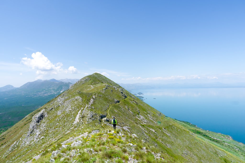
Maja e Taraboshit

The total distance of this hike is 17.85 km, with an elevation gain of 710m, and the highest altitude is 651m at Maja e Golishit. The ridge is 2km long, so you’ll have plenty of time to take in the breathtaking views. The best time to do this hike is during spring when the temperatures are not so high. Remember, there is no water source along the way, so bring enough water to stay hydrated.

To start the hike, head to the village of Shiroke, which is located about 12km from the city of Shkodra. The trailhead is easy to find, and plenty of parking is available. From there, you’ll start climbing up the hill until you reach the first viewpoint. The view from here is already impressive, but the best is yet to come!

Continue along the ridge, and you’ll soon reach the highest hike point at Maja e Golishit. The view from the top is simply breathtaking! Take a break here and enjoy the scenery before continuing back.

Once you reach Maja e Golishit, you’ll have a 360-degree view of the surrounding mountains, the Shkodra Lake, and the Adriatic Sea. It’s incredible to stand on top of the world, looking out over such a vast and beautiful landscape.

After taking in the view, it’s time to head back down the trail. Be sure to take plenty of photos to remember this incredible hike!

In conclusion, hiking from Shiroke to Maja e Golishit is an unforgettable experience. It’s an easy hike, but the views are simply spectacular. Remember to bring enough water, especially during the hot summer months, and take your time to enjoy the scenery. We hope you enjoy this hike as much as we did!
Share this guide

Questions and comments

Ask me about this hike

Leave a comment or a trail report

Your email is never shown. A first comment appears once I have read it.

Trail report

Through my lens

More from Albania

All my photographs

Keep exploring

More from Accursed Mountains

All Albania guides
Granit Temaj

Get my new stories by email

Be the first to know when I come back from the mountains with a new route.

You will get one email to confirm. Unsubscribe any time. Privacy

Read the guide

Trail alerts

An email when someone reports how the path is, or when I update the guide. Nothing else, and one click stops it.

You confirm it by email first. Your address is used for these alerts only. Privacy

License this photograph

Tell me what it is for. I answer within a few days with a price and the licence.

Your name and email are used only to answer this request.

Newsletter

Get my new stories by email

Be the first to know when I come back from the mountains with a new route.

You will get one email to confirm. Unsubscribe any time. Privacy