Jezerca lakes from Valbona, a challenging off-trail hike

· updated · 1 min read
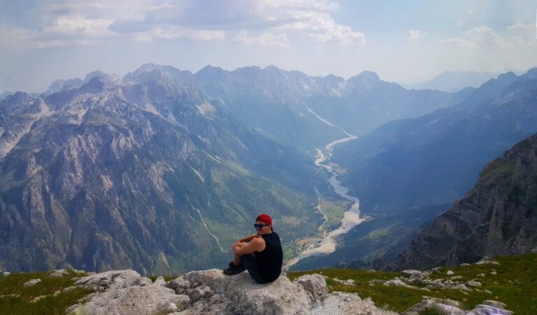
A hiker above a turquoise lake beneath the rocky peaks of the Jezerca Lakes in Albania
Jezerca lakes from Valbona, Albania
Distance
10.0 km
Ascent
+1,188 m
Descent
−392 m
High point
2,150 m
Difficulty
Challenging
Water
Last water source in Kukaj village

The route

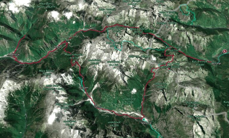
Jezerca lakes from Valbona, on the map

From my own GPX track. Move along the elevation profile or along the line on the map: both show the same point.

Distance10.0km
Ascent+1,188m
Descent−392m
High point2,150m
DifficultyChallenging

Walking time at your paceAn estimate without breaks, worked out from the distance and the climb.

  • Relaxed7 h 30 min
  • Average6 h
  • Fast4 h 50 min

Elevation

Elevation profile of Jezerca lakes from Valbona, a challenging off-trail hikeStarts at 902 m, climbs 1,188 m in total to a high point of 1,986 m after 7.0 km, and finishes at 1,698 m; 9.5 km in all.1,000 m1,500 m2,000 m0 km1 km2 km3 km4 km5 km6 km7 km8 km9 kmValbonaThe pass (the pyramid) · 1,986 mJezerca lakes

How steep

  • 2.5 kmUnder 8%
  • 2.5 km8 to 15%
  • 2.6 km15 to 25%
  • 1.9 kmOver 25%

In two parts

Embed this map

Paste this into your page or post (in WordPress: a Custom HTML block). The map stays up to date with the guide, and the link under it leads your readers to the full guide.

Plan the trip

Sleep

Stays near Valbona

Guesthouses fill up in summer: book early.
Get there

Transfers and tours around Valbona

Or drive: the route card above has directions to the start.
What to pack15 things, for a summit, a long day, a swim

Every hike

For the summit

For a long day

Water and sun

The light for photographs

Today at The pass (the pyramid): sunrise 06:09, sunset 16:39.

At The pass (the pyramid), 1,986 m, in local time (Europe/Tirane), with an open horizon: the mountains around can hide the sun sooner.

In short

This challenging off-trail hike goes from Valbona in Albania to the Jezerca lakes. The post gives a distance of 10 km and a high point of 2,150 m at the pass; the last water source is in Kukaj village.

Jezerca lakes (also called as Buni i Jezercës) is an amazing outdoor destination located near the highest peak of the Accursed Mountains (Prokletije), Maja Jezercë. The easiest way to go to the lakes is from Vusanje in Montenegro. But, if you want an off-trail adventure, then you definitely should try going from Valbona Valley National Park in Albania.

A hiker stands in a turquoise lake beneath the rocky peaks and green slopes of the Jezerca Lakes

How to get to Valbona Valley National Park

Valbona Valley is 22 km from the city called Bajram Curri. Reaching Bajram Curri from Tirana takes around four hours. The bus station in Tirana is in front of Asllan Rusi Sports Center. 

Another way to reach Bajram Curri is from Prishtina, Kosovo. First, you go from Prishtina Main Bus Station to Gjakova Bus station and then from Gjakova take the bus to Bajram Curri.

About the Jezerca lakes hike

A hiker above a turquoise lake beneath the rocky peaks of the Jezerca Lakes in Albania
The hike to Jezerca lakes starts from the Valbona National Park, near the school. You take the path to Kukaj village, where you can find the last water source. Then the trail runs through boulders and meadows, eventually entering the beech forest until you reach a small grassy plateau with a mountain hut. From here the hike becomes steeper and the ascent to the northwest leads to the pass at 2150m altitude. After you reach the pass (also called the pyramid) turn left, and start descending into an off-trail. Total distance from the pyramid to Jezerca lakes is around 3 km, and the elevation loss is around 390 m. The total distance from Valbona to the lakes is 10 km.

Points of interest:

Starting point: Valbona Valley National Park.

Starting altitude: 901 m/alt

Elevation gain: 1’188 m

Elevation loss: 392 m

Share this guide

Questions and comments

13 comments

  1. Akos

    Hello, thank you for this blog, I want to do the same hike, but I need some technical info. Do I need a ice axe, and other pro stuff for this hike? Or a good hiking boots and good condition will be enough? So from kukaj, I won’t find any drinkable water? 3 of us want to do wildcamping in this region

    Reply

    1. Granit Author

      No, you don’t need ice axe or any climbing stuff. Proper hiking boots, a MUST!

      You can filter the water from the lake, however, a there is no water source from Kukaj to the lakes.

      Reply

  2. Valdrin

    A osht terreni shum.i veshtire ? A munden te ngjitet qdo kush apo duhet te jene me eksperienc dhe te forte ?

    Reply

    1. Granit Author

      Pershendetje,

      Po, tereni eshte i veshtire. Plus, nuk eshte i shenjezuar si duhet. Te kisha sugjeru te e besh ngjitjen nga Vuthajt.

      Reply

  3. Lotte

    Hello! Thanks for your great blog! I was sondering if you need a permit for this hike? It seems a bit unnecessary if you`re crossing the border again on the same day, in the middle of the mountains, but I guess in theory you need one?

    Reply

    1. Granit Author

      Hey Lotte,

      No you don’t need one. You will go through the border but no cross it. You will be in Albania all the time 🙂

      Happy trails!

      Reply

  4. shavaiz

    Your comment is awaiting moderation.
    Hello there,

    Do you think it is possible to include this on the way from Valbona to Theth hike or is it too difficult to manage both in one go?

    If its possible, How to do the hike START point & how much time approx it will take from Valbona to Theth including visit to Lake. lets say hike from valbona startig at 6:30 am.

    Thank you for your kind guidance.

    Reply

    1. Granit Author

      Hi, no it is totally not doable in my opinion in one day.

      So, what I would suggest:
      Day 1: Valbona – Lakes, camp there
      Day 2: Lakes – Peja Pass – Theth

      Reply

  5. Wolf

    Do you think it is possible to do this as a day trip round trip from Valbona? Thinking of doing this as the second day after Theth — Valbona.

    Reply

    1. Granit Author

      Hm, it is doable, but quite intense.

      Reply

  6. Wolf

    Final question 🙂
    The picture at the top of this article. Is that on the wikiloc trail or did you have to go off trail to get that amazing view :)?

    Reply

  7. Flore

    Hi! How do I get from the lakes to the Peja Pass? Do you have a GPX or recommended trail?

    I’m going to hike from Teht-Valbona (day 1), Valbona – Lakes (day 2), and still have 2/3 days to fill with a trekking (with tent). I was planning to go over Kosovo and then to the Peja Pass, sleep on top and then descend back to Teth, does this seem doable?

    Reply

    1. Granit Author

      Why you don’t go, Theth – Valbone – Cerem – Vusanje – Lakes – Peja Pass – Theth?

      Reply

Leave a comment or a trail report

Your email is never shown. A first comment appears once I have read it.

Trail report

Through my lens

From this walk

All my photographs

Keep exploring

More from Accursed Mountains

All Albania guides
Granit Temaj

Get my new stories by email

Be the first to know when I come back from the mountains with a new route.

You will get one email to confirm. Unsubscribe any time. Privacy

Read the guide

Trail alerts

An email when someone reports how the path is, or when I update the guide. Nothing else, and one click stops it.

You confirm it by email first. Your address is used for these alerts only. Privacy

License this photograph

Tell me what it is for. I answer within a few days with a price and the licence.

Your name and email are used only to answer this request.

Newsletter

Get my new stories by email

Be the first to know when I come back from the mountains with a new route.

You will get one email to confirm. Unsubscribe any time. Privacy