Maja e Hasanit (Hasan’s Peak) beautiful hike near Peja

· updated · 1 min read
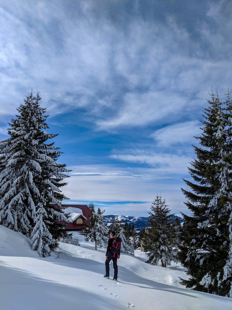
A hiker stands on a snowy ridge at Maja e Hasanit, overlooking forested Kosovo mountains
Maja e Hasanit (Hasan’s Peak) beautiful …, Kosovo
Distance
6.0 km
Time
1.5–2 h
Ascent
+300 m
Descent
−677 m
High point
1,900 m
Difficulty
Easy

The route

Maja e Hasanit (Hasan’s Peak) beautiful …, on the map

From my own GPX track. Move along the elevation profile or along the line on the map: both show the same point.

Distance6.0km
Time1.5–2 h
Ascent+300m
Descent−677m
High point1,900m
DifficultyEasy

Walking time at your paceAn estimate without breaks, worked out from the distance and the climb.

  • Relaxed3 h 55 min
  • Average3 h 5 min
  • Fast2 h 30 min

Elevation

Elevation profile of Maja e Hasanit (Hasan’s Peak) beautiful hike near PejaStarts at 1,215 m, climbs 300 m in total to a high point of 1,918 m after 4.4 km, and finishes at 1,249 m; 8.6 km in all.1,500 m0 km1 km2 km3 km4 km5 km6 km7 km8 kmLipaMaja e Hasanit · 1,918 m

How steep

  • 0.6 kmUnder 8%
  • 4.2 km8 to 15%
  • 2.5 km15 to 25%
  • 1.3 kmOver 25%

In two parts

Embed this map

Paste this into your page or post (in WordPress: a Custom HTML block). The map stays up to date with the guide, and the link under it leads your readers to the full guide.

What to pack17 things, for a summit, snow

Every hike

For the summit

Snow and ice

The light for photographs

Today at Maja e Hasanit: sunrise 06:11, sunset 16:33.

Today at Maja e Hasanit: sunrise 06:11, sunset 16:33.

At Maja e Hasanit, 1,918 m, in local time (Europe/Belgrade), with an open horizon: the mountains around can hide the sun sooner.

In short

Maja e Hasanit is an easy hike from Lipa near Peja, Kosovo. The route is 6 km, takes 1.5 to 2 hours and gains 300 m, reaching 1,900 m. The last water source is by the restaurant, so carry 1.5 to 2 litres.

Maja e Hasanit (Hasan’s Peak) is a short and beautiful hike into a mountain peak located near the city of Peja, Kosovo. If you are planning an outdoor day activity – a moderate hiking trip, this place is perfect. This destination is not a very popular outdoor destination, but quite a beautiful one.

A hiker stands on a snowy ridge at Maja e Hasanit, with sunlit peaks stretching across the horizon

How to get there

The starting point for this hike is a village called Lipa. Going in Lipa is easy and the road is paved, but during the winter it may be difficult because of the snow.

First, you need to go to the city of Peja. Peja is located 85 km from Prishtina, around 1 hour and 30 minutes drive. Then, you will follow the road to a village called Novoselle, through Vitomerica. When reaching the crossroad in Novoselle, turn left, and then after 500 meters turn right. After this, just follow the road for around 30 minutes.

About the Maja e Hasanit hike

A hiker stands on a snowy ridge at Maja e Hasanit, overlooking forested Kosovo mountains

In Lipe, there is a restaurant, and from there, you need to continue ascending through the road, and there you can find the last water source. During winter, you cannot reach the restaurant in a small car, therefore, you need to walk through the road. After a while, you will reach a road where you need to get into the forest, in order to continue to the Maja e Hasanit edge. There is no signed trail, but just try to pass the forest, and you are almost to the peak.

During the winter this hiking trail is perfect for snowshoeing.

This hike is an easy one, the total distance is around 6 km (during winter around 10 km), therefore you need around 1.5-2 liters of water.

Points of interest:

Starting point: Lipa, Peja

Starting altitude: 1’600 m/alt

Highest altitude: 1’900 m/alt

Elevation gain: 300 m/alt
Share this guide

Questions and comments

Ask me about this hike

Leave a comment or a trail report

Your email is never shown. A first comment appears once I have read it.

Trail report

Through my lens

From this walk

All my photographs

Keep exploring

More from Accursed Mountains

All Kosovo guides
Granit Temaj

Get my new stories by email

Be the first to know when I come back from the mountains with a new route.

You will get one email to confirm. Unsubscribe any time. Privacy

Read the guide

Trail alerts

An email when someone reports how the path is, or when I update the guide. Nothing else, and one click stops it.

You confirm it by email first. Your address is used for these alerts only. Privacy

License this photograph

Tell me what it is for. I answer within a few days with a price and the licence.

Your name and email are used only to answer this request.

Newsletter

Get my new stories by email

Be the first to know when I come back from the mountains with a new route.

You will get one email to confirm. Unsubscribe any time. Privacy