For the trail · alpventurer.com/oshlak
Oshlak mountain, and its beautiful ridge
Oshlak mountain · Kosovo
- Difficulty
- Moderate
- Water
- No water sources; carry 1.5–2 litres
- Parking
- Free
In short
A moderate, well-signed hike from Prevalla in Kosovo, with forest, meadow and ridge views over the Sharr Mountains. The post gives a total distance of 12 km and a high point of 2,212 m; there are no water sources, so carry 1.5–2 litres.
The route: Trail from Prevallë village
- Distance
- 12.0 km
- Ascent
- +789 m
- Descent
- −770 m
- High point
- 2,212 m
- Lowest point
- 1,524 m
A Prevallë: 42.17458, 20.96211▲ Maja e Oshlakut: 42.19671, 20.89166
Walking time, without breaks
- Relaxed7 h 5 min
- Average5 h 40 min
- Fast4 h 30 min
How steep
- Under 8% 7.7 km
- 8 to 15% 4.3 km
- 15 to 25% 4.0 km
- Over 25% 0.2 km
In two parts
- Up to Maja e Oshlakut 8.6 km · +744 m
- Back down to Prevallë 7.6 km · −697 m
The route: Trail 1 km from Prevallë village
- Distance
- 11.6 km
- Ascent
- +879 m
- Descent
- −869 m
- High point
- 2,242 m
- Lowest point
- 1,418 m
A Prevallë: 42.18141, 20.94773▲ High point: 42.19682, 20.89150
Walking time, without breaks
- Relaxed7 h 40 min
- Average6 h 5 min
- Fast4 h 55 min
How steep
- Under 8% 2.6 km
- 8 to 15% 3.1 km
- 15 to 25% 4.9 km
- Over 25% 1.1 km
In two parts
- Up to the high point 5.9 km · +851 m
- Back down to Prevallë 5.8 km · −844 m
What to pack
Every hike
- Water: about 2 litres (half a litre an hour), all of it: no water on the way
- Food and snacks for the day
- Rain jacket
- A warm layer (fleece or light down)
- Sun cap, sunglasses and sun cream
- Boots or trail shoes with good grip
- Phone with the map offline, and a power bank
- Small first aid kit
- Headlamp, in case it gets late
- Some cash and your ID
For the summit
- Hat and gloves: it is colder and windier at the top
- Walking poles, for the way down
The guide
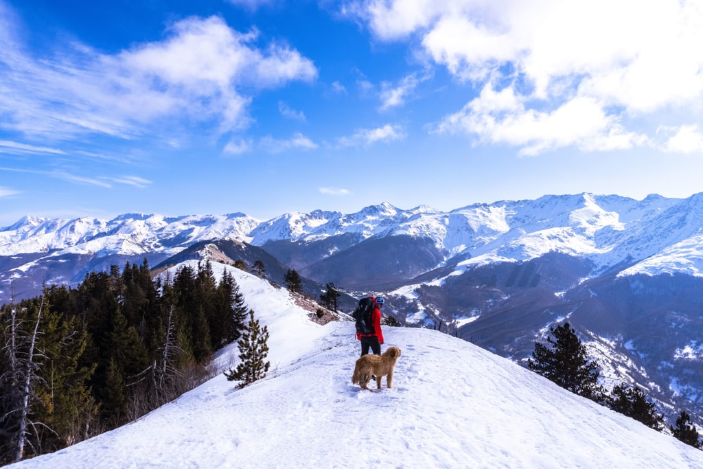
Oshlak mountain (also called Osljak) is one of the first trails I’ve done, a moderate hike with beautiful views. The ridge of this mountain is very beautiful and it is one of the longest mountain ridges in the Balkans, especially the view of the Sharr mountains range from this mountain is very beautiful.
How to get there
The starting point for this trail is near the touristic village of Prevalla, Prizren.
The first way is from the city of Prizren; you will go through some villages and Sharr Mountains range, 1.5 km before arriving in Prevalla, you will see a sign, Oshlak. There is the starting point.
The other way is to go through the town of Shterpce. Once you arrive in Shterpce you continue to Brezovica. Follow the road to Prevalla. When you pass Prevalla and after 1.5 km you will see the sign, Oshlak.
About the Prevalla – Oshlak hike

This is a moderate hike starting from Prevalla, which is easy to follow and very well signed. First, you go through a forest, which takes around 1 hour. After this, you go to a meadowy hill which you will quickly climb. Then, you will reach the ridge, and the other part of the trail is a very easy hike, but definitely the most beautiful one. The views from the ridge are very beautiful, and surely you will like them. On the left side, you will see the Sharr Mountains range, in front of you, you will see the city of Prizren and Pashtrik peak, and on the right side, you will see the Black peak and Pashallore peak. The highest peak of this mountain is 2’212 m/alt and the total distance is 12 km.
There isn’t any water source, therefore take 1,5-2 liters of water.
Points of interest:
Starting point: Prevalla, Kosovo
Starting altitude: 1’417 m/alt
Highest altitude: 2’212 m/alt
Elevation gain: 789 m/alt